Friends of Grays Harbor
has just released an important study on the economic impacts of crude
oil transport to Grays Harbor.
The report can be accessed by visiting http://fogh.org and click on IMPACTS OF CRUDE OIL ON GRAYS HARBOR’S ECONOMY to download the PDF.
This
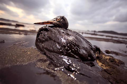
study confirms that the risk of bringing crude oil to the Harbor, will
jeopardize Washington’s Coast and devastate the estuary and impact the
livelihoods and quality of life of thousands of residents. We hope you
will comment on the Draft EIS. Please come to one of the public hearings to be
held on this project. October 1, 2015 at the Satsop Business Park,
Flextech Building, (Building 100), 150 Technology Way, Elma Washington
or October 8, 2015 at the D & R Threatre 205 South I Street,
Aberdeen, Washington. Each hearing will take public testimony from
1:30pm - 4:30pm and again at 6:00pm - 9:00pm. The doors are open from
1:00pm - 9:00pm on those two days. You can learn more at http://www.ecy.wa.gov/
Update: (new location) There will be a rally of citizens on October 8 on the Heron side of I Street, near the D&R Theater in Aberdeen beginning at 5:00pm on October 8th.
Please attend and bring a few hundred of your closest friends. Crude oil cannot be mitigated.
Two other recent studies are discussed below:
Two other recent studies are discussed below:
The Impacts of a Grays Harbor Oil Spill, in 13 Slides
How Big Oil jeopardizes Washington coastal tourism and the Quinault Nation.
Tarika Powell and Eric de Place September 17, 2015 Sightline Institute
Three large oil terminals proposed for Grays Harbor could undermine the region’s economy and local culture. That’s the takeaway from two recent economic analyses: first, a study on coastal recreation in Washington from the Surfrider Foundation and marine technology firm Point 97; then, Economic Impacts of Crude Oil Transportation on the Quinault Indian Nation and the Local Economy, published by economic consulting firm Resource Dimensions.
These reports help clarify the real threat that oil transport poses to Grays Harbor. But since most people don’t have time to thumb through such detailed findings, Sightline commissioned the following graphics to sum up the key points.
Over forty percent of Washington residents travel to the coast each year; their top recreational activities are beachgoing, scenic enjoyment, wildlife viewing, photography, and hiking/biking.

Original Sightline Institute graphic, available under our free use policy. Data Source: Surfrider Foundation.
Coastal visitors spend an estimated $481 million dollars per year on recreation and tourism trips. An oil spill in the bay could do tremendous harm to businesses that are dependent on tourism dollars.

Original Sightline Institute graphic, available under our free use policy. Data Source: Surfrider Foundation.

Original Sightline Institute graphic, available under our free use policy. Data Source: Resource Dimensions.
An increased volume of oil going into and out of Grays Harbor would increase the risk of spills, so Resource Dimensions studied three oil spill scenarios.

Original Sightline Institute graphic, available under our free use policy. Data Source: Resource Dimensions.

Original Sightline Institute graphic, available under our free use policy. Data Source: Resource Dimensions.
*** continued below***
Quinault fishers’ catches and harvest include salmon, rockfish, white sturgeon, halibut, sardines, Dungeness crab, and razor clams.

Original Sightline Institute graphic, available under our free use policy. Data Source: Resource Dimensions.
Fishing and select Quinault businesses, mainly in the tourism industry, generate 668.5 direct jobs. Purchases made by these businesses generate $84.7 million in revenues for suppliers and support 239 other jobs in the region.

Original Sightline Institute graphic, available under our free use policy. Data Source: Resource Dimensions.
Resource Dimensions analyzed the potential for job losses, personal income declines, and missed business revenue that would result from the possible spill scenarios.

Original Sightline Institute graphic, available under our free use policy. Data Source: Resource Dimensions.
A loss of jobs and income would be particularly devastating for the Quinault reservation, where the median income is half that of Washington as a whole.

Original Sightline Institute graphic, available under our free use policy. Data Source: Resource Dimensions.
An estimated 1,380 Quinault Indian Nation members rely on subsistence fishing and harvesting, which makes up about 20% of their diet.

Original Sightline Institute graphic, available under our free use policy. Data Source: Resource Dimensions.
If subsistence harvesting were unavailable due to an oil spill, the cost of replacing the lost protein content in the diet would be $260.16 per person per year. Since the average family size on the reservation is 3.74 people, replacing protein content would cost the average family $1,040.64 per year.

Original Sightline Institute graphic, available under our free use policy. Data Source: Resource Dimensions.
Even if no spill occurs, there will still be income losses. Lost fishing time from increased train traffic and marine vessels could cost a fisher up to $1,185 per year. Moreover, fishing nets can be damaged by propellers or oil spilled during regular business, costing a hefty $2,500 to replace.

Original Sightline Institute graphic, available under our free use policy. Data Source: Resource Dimensions.
A Grays Harbor oil spill would also impact tribal weavers, who make goods including baskets, jewelry, and clothing.

Original Sightline Institute graphic, available under our free use policy. Data Source: Resource Dimensions.
These two studies provided valuable data on the economic impacts of an oil spill at Grays Harbor and highlighted what is at stake beyond financial loss. Because it’s difficult to assign a market value to the human impacts of oil spills, they are all too often ignored.
Thanks to Devin Porter at Goodmeasures.biz, who designed these graphics.
No comments:
Post a Comment